
January is supposed to be one of the safest months for Indonesia’s peatlands. The rainy season is at its peak, flooding rivers and saturating the ground across Sumatra and Borneo. In late 2025, the rains had been so heavy they triggered massive flooding that killed more than 1,200 people in Aceh alone.
And yet, in the middle of all that water, something unexpected was happening underground. Satellites were picking up thousands of fire hotspots burning across Indonesian peatlands, which raises a question that scientists and watchdogs found deeply unsettling.
If fires were spreading during the wet season, what would happen when the dry season returned? Well, that’s something to talk about surely.
What The Report Said

The findings came from Pantau Gambut, an independent monitoring group that tracks the condition of Indonesia’s peatlands using satellite data. In January 2026, the group recorded 5,490 fire hotspots across peatland areas nationwide.
Official government data, using a different detection method based on NASA satellite imagery, recorded 110 hotspots for the same month, up from just 29 in January 2025 and 18 in December 2025.
Although the two figures relied on different criteria and could not be directly compared, both pointed in the same direction: fires were increasing at a time of year when they historically had not been a major concern.
West Kalimantan and Aceh were the hardest-hit provinces, recording 2,216 and 1,444 hotspots respectively. More than half of all the hotspots Pantau Gambut identified, specifically 3,266 of them, were located inside peat ecosystems that had been officially designated for conservation and research.
Another 1,824 hotspots were found inside company concessions, with 1,617 of those falling within oil palm plantation areas.
So, Why?

To understand why fires were spreading during rainfall, researchers looked at what had happened to the peatlands themselves over decades of land use.
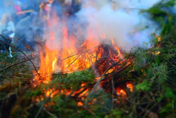
Peat soil is made up of partially decomposed plant matter that has built up over thousands of years in waterlogged conditions. In their natural state, peatlands stay wet enough to resist burning.
But across large parts of Sumatra and Borneo, plantation and logging companies had dug drainage canals to dry out the peat for cultivation, lowering the water table and transforming the soil into a layer of flammable organic material.
In those degraded areas, even a short break in the rain was enough to start a fire. Indonesia’s meteorological agency recorded up to 11 consecutive days without rain in parts of West Kalimantan in mid-January 2026.
On healthy mineral soil, 11 dry days would not typically cause fires. But on peat that had already been drained, the surface dried out quickly enough to ignite.
Once peat fires started, they burned underground, making them difficult to detect from above and nearly impossible to put out with light rainfall. They kept smoldering even as the wet season continued around them.
Pantau Gambut campaigner Putra Saptian said the spike showed that fire risk in peat landscapes was no longer tied to the traditional dry season. It was now being driven by degraded hydrology and ongoing land-use pressure.
Peat’s Double Danger

One of the more striking aspects of the January data was that the provinces most affected by fires had also recently experienced severe flooding. West Kalimantan had seen flooding in early January 2026. Aceh had been hit by Typhoon Senyar in November 2025. The same landscapes were burning and flooding within weeks of each other.
Scientists explained that this was not a contradiction. It was a direct consequence of peat degradation. When drainage canals lowered the water table and repeated burning caused the peat to break down and compact, the ground gradually sank.
As the elevation dropped, the land lost its ability to absorb and hold water. During heavy rains, water that would once have been stored in the peat flooded across the surface instead. During dry spells, the thin layer of remaining peat dried out and caught fire.
A previous Pantau Gambut report found that nearly half of Indonesia’s peatlands were vulnerable to flooding due to degradation, with about 6 million hectares classified as highly vulnerable.
The fires also produced toxic haze that spread across parts of Borneo. Pontianak, the capital of West Kalimantan, had been covered in smoke since January, even though it recorded fewer hotspots than surrounding districts.
Prevailing winds carried smoke from fires outside the city’s boundaries directly over its population. In February 2026, a 67-year-old woman in a nearby district died after severe respiratory distress, with hospital staff noting that the smoke had aggravated her underlying asthma.
Studies had previously shown that peat smoke contained formaldehyde, benzene, carbon monoxide, and nitrogen dioxide, all of which caused respiratory and cardiovascular harm even at relatively low concentrations.
Indonesia’s Familiarity
Indonesia had faced this problem before. In 2015, peat fires spread smoke across Southeast Asia, and a later study by researchers at Harvard and Columbia universities estimated that exposure to that haze may have contributed to up to 100,000 premature deaths across the region.
In response, then-President Joko Widodo established a dedicated peat restoration agency in 2016, which reported restoring about 1.6 million of the 2.6 million hectares it had been tasked with rehabilitating before its mandate ended in December 2024.
After the agency dissolved, no institution took over its specific responsibility for peat restoration. At the same time, the Ministry of Environment and Forestry was split into two separate ministries, creating uncertainty about which body was responsible for peatland protection.
Many peat ecosystems sat within forested land, making coordination between the two ministries essential. Pantau Gambut said that monitoring systems built to track water levels and restoration progress across peatlands had not been operating effectively since the restructuring.
The concern was not only about the present. Pantau Gambut warned that the risk could intensify significantly if El Niño conditions developed in 2027, as the climate pattern typically brought prolonged dry spells to Indonesia.
In 2015, El Niño had extended the dry season long enough to turn millions of hectares of degraded peat into tinder. With restoration infrastructure weakened and oversight fragmented, watchdogs said the country was less prepared to handle that kind of season than it had been just two years earlier.
“The absence of real-time monitoring and weak peat restoration signal a setback in ecosystem protection from fires,” Pantau Gambut said in a statement released alongside its January data.
Sources:
Leave a Reply